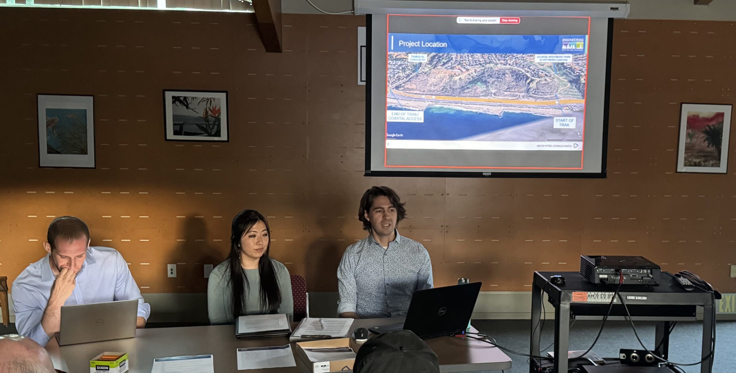
(Left to right) Traci Park’s field deputy Michael Amster, Krystin Ly and Goodwin Warton presented Lateral Trail ideas.
The design of the Pacific Palisades Trail (formerly the Lateral trail)’s design, which will connect George Wolfberg Park in Potrero Canyon, with Temescal Canyon Road and ultimately Will Rogers State Park, was discussed at an August 21 Meeting at the Palisades Library.
Hosting the meeting was Kristen Ly, L.A. City’s Bureau of Engineering of Project manager and Goodwin Warton of Geosyntec Consultants.
Ly made it clear that “This is a separate project from the bridge.” She said the trail had been approved in a 2022 Amendment to Coastal Development Permit by the Coastal Commission. (History below.)
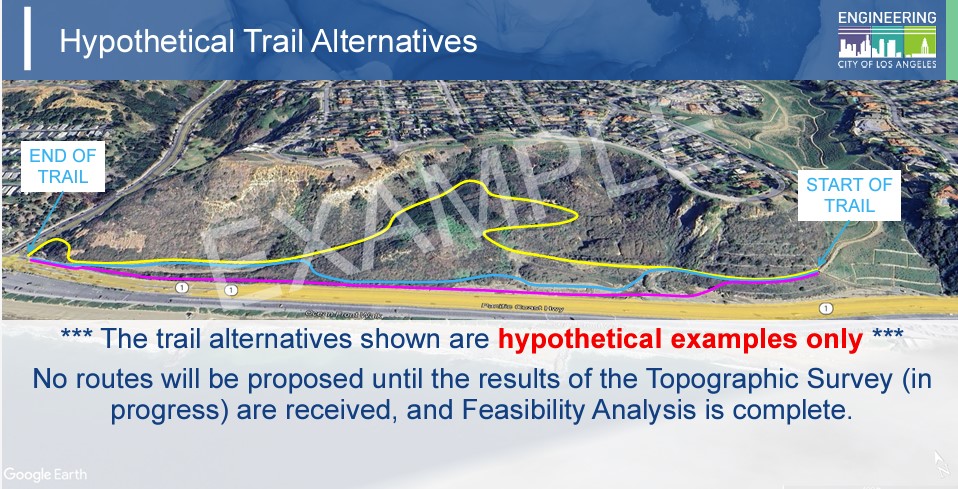
The sketches that Warton showed were merely to provoke discussion and to listen to suggestions from Palisades residents.
“This is not a final design,” Ly said and noted that Warton would take the suggestions to work on a final design that would come back for community approval.

These are just suggestions, they are not the final trail. Make your voice heard take the survey below.
Once there is a final design, the City would reach out to Caltrans and Coastal. The plan will need a Caltrans right-of-way, and Coastal approval. Once the City has that the construction of the proposed 12-foot-wide trail co project could go forward.
The city does not have a final cost for the project, but 2022, BOE requested $3.4 million in the City’s budget to cover their projected cost for the total project
Subsequently, Representative Ted Lieu secured $1.15 million for the trail. At this meeting, Ly did not have an estimate for how much this trail would cost or the timeline. At a prior meeting it was noted it would take several months for a design, City would have to secure an encroachment permit or create a Joint Use Agreement with Caltrans. The environmental phase could last two years, it would take about a year to construct a trail. Completion was estimated for 2027.
At the meeting Warton asked people to fill out a public feedback questionnaire. It is below and readers are invited to fill it out. Warton needs responses by August 30 click here.
Sharon Kilbride, who was a former President of the Pacific Palisades Task Force on Homelessness, asked for fencing and signage. There were three fires started in the Via de las Olas bluffs and it took volunteers years to remove the 60 camps located in the brush before the very high fire severity zone signs went up prohibiting camping.
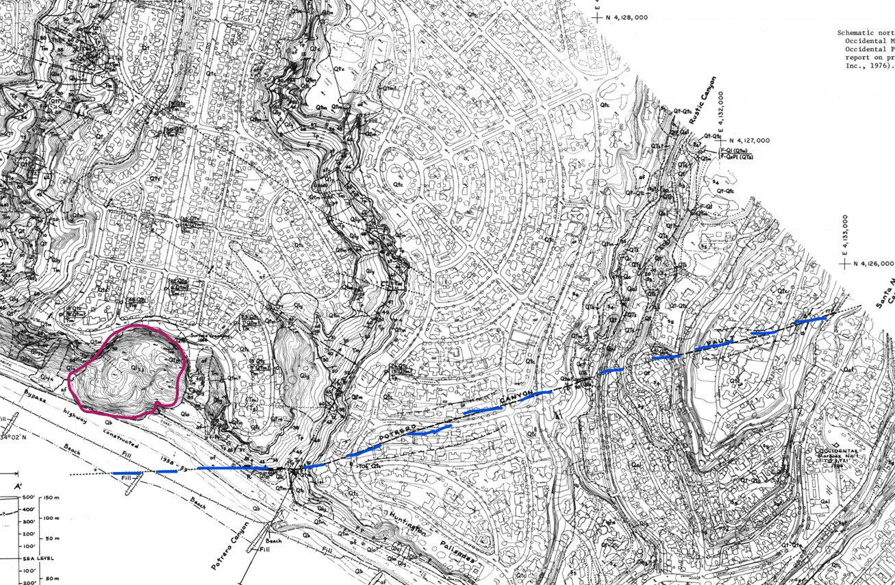
Local historian Randy Young suggested that Geosyntec look at the three geology studies that were done of the area documenting the Potrero Canyon fault and the Santa Monica fault. Young also wanted to alert Warton that there had been two gas stations located at the base of Potrero. “This area has been studied extensively,” Young said, noting that before anything is done, “A good geology report is important.”
He also told Warton that the site that the trail would go on should be checked, not only because of Occidental Petroleum, which had a drill site there, but because some of the infill that had been put in Wolfberg Canyon by Rick Caruso was considered toxic and piled near the site where the trail might go.
One of the trails shown curved up the hill before coming back to Temescal Canyon Road, and David Card said, “I would not recommend going up on the slope.” He mentioned that Rob Hancock, who used to work with BOE was aware of the geology.
The 1958 Killer slide, started just below Via de las Olas and slid onto the highway, killing a man and causing PCH to be routed closer to the ocean. “We need a fence separating the highway and the people on the trail,” Card said.
Some worry that people will not walk the extra half mile to go to Temescal to cross at the light, but instead dash across PCH, because the ocean is just across from the base of the George Wolfberg Park.
Chris Spitz noted the need for public safety. “We need fencing along PCH to discourage people from jumping across,” she said. “How can we be sure gates are locked at night?”
Another person wondered who would do the long-term maintenance on the trail. L.A. City Recreation and Parks would be responsible for maintenance.
Another person wondered if the trail could be used by bikes, too.

An earthquake fault (blue line) runs through Potrero Canyon. The area outlined in red was the site of the Killer Slide of 1958, which pushed PCH closer to the ocean.
History of the Trail
When lots were sold in Potrero Canyon to fund the completion of George Wolfberg Park, one of the Coastal Commission requirements was the park have access to the beach. In numerous documents, access is a requirement and a bridge or some other crossing must be provided.
In a 2014 Costal Commission Amendment to the original Coastal Development Permit (CDP), noted “In order to require the City to provide maximum public access, the Commission revises Special Condition 25 to require the City to include the lateral access trail as a separate line item in the project budget and submit biannual progress and budget reports on its status. . . . .
“Additionally, the Commission imposes Special Condition 28, which requires the City and its contractors and engineers to work with Caltrans and submit, a detailed analysis of the feasibility of a pedestrian beach access crossing at Pacific Coast Highway. The analysis (MARRS study) shall consider alternative designs, including but not limited to a pedestrian bridge (similar to that envisioned by the applicant), a pedestrian tunnel, and a signalized at-grade pedestrian crossing over the highway.”
In that 2016 MARRS Memorandum, the City was advised to “Improve the Existing Trail to Temescal Canyon Road From Potrero Canyon Park, pedestrians must walk approximately 1/2 mile west, parallel to PCH on the north side, to an existing signalized crossing at an intersection at Temescal Canyon Road.
“This trail is a poorly graded existing path that joins the trail from Potrero Canyon Park. The City would need to grade, fence, sign and maintain the path to provide proper safety and encourage its use. These improvements could be done in conjunction with one of the other alternatives.”
In this study, required by Coastal, other beach access at to be examined, such as a crossing on PCH, a tunnel under the road, but the best solution presented was the pedestrian bridge.
There is separate funding for the trail and for the bridge. Money from one cannot be used for the other and both are now required for access by the Coastal Commission.
As Community Council At-large representative Chris Spitz pointed out the City had come under “Violations of the Coastal Act, including but not necessarily limited to, the delay in construction of the lateral trail required by Special Condition 25 of the underlying CDP (Coastal Development Permit).
“The applicant also failed to furnish the Commission with the required biannual progress reports, denoting the expenditure of funds, required by the underlying CDP since 2016. Any non- 5-91-286-A13 (City of Los Angeles) 32 exempt development activity conducted in the coastal zone without a valid coastal development permit, or which does not substantially conform to a previously issued permit, constitutes a violation of the Coastal Act.”
The City is now providing the required progress reports.

Scrap the trail and the bridge and re-install the crosswalk directly across from the Lifeguard Headquarters and restrooms. In ground flashers and an actual light just like at the Palisades Bowl. It would act as a traffic calming device and be a more fiscally sane alternative to the low-traffic alternatives.
The community is encouraged to complete the online trail survey, which can be accessed via a link on the PPCC website home page: http://www.pacpalicc.org. Deadline to submit survey comments: 5pm Friday, August 30.
Thank you,
Chris Spitz, PPCC At-large rep
Doug,
Caltrans won’t give permission for it, I was told.
sue
Dear Sue ; Why don’t we have two trials, one high with viewing area and one along the highway. That whole area should be cleaned up and made into a park. gilbert dembo